
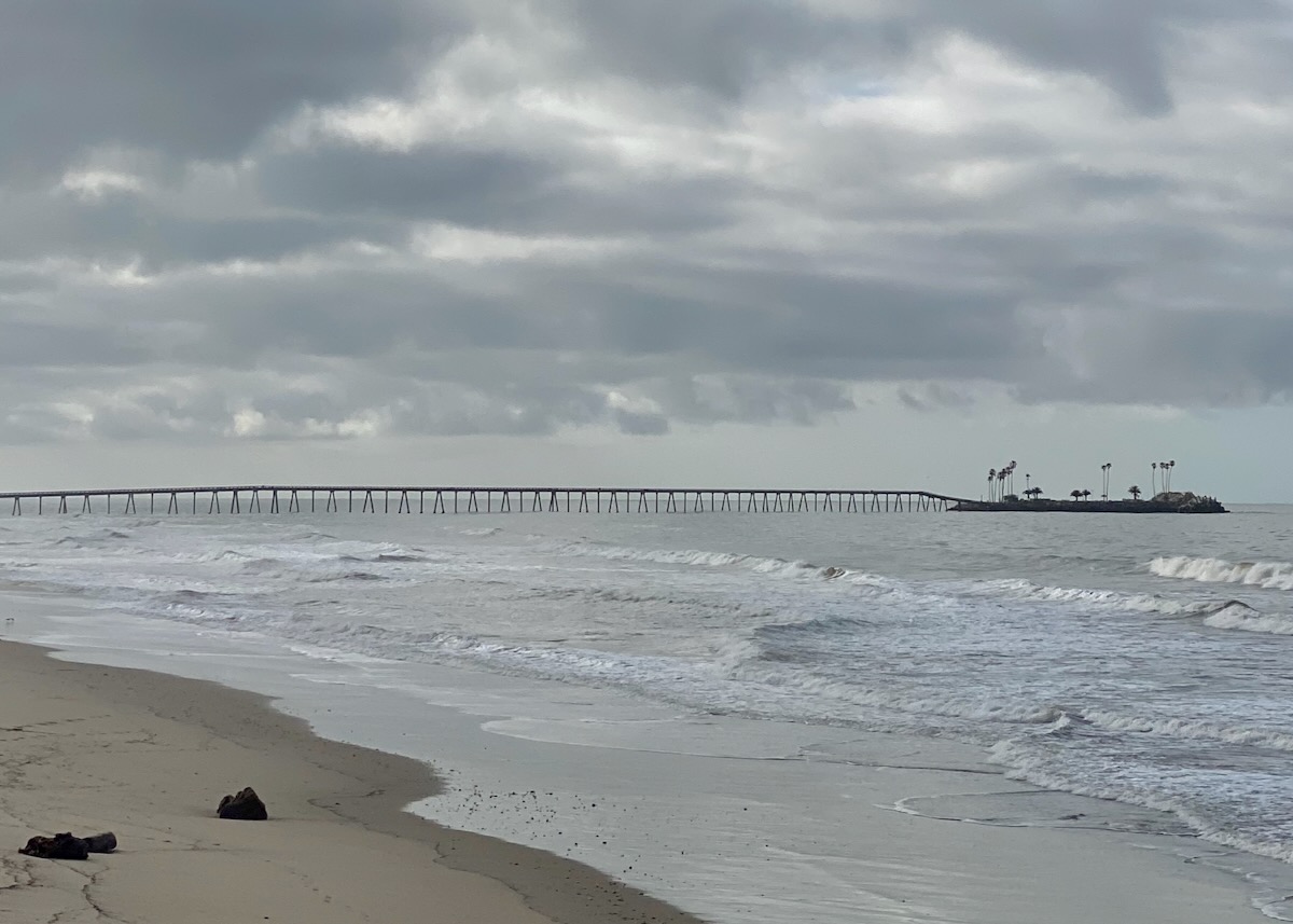
What’s happening with Rincon Island? We live in La Conchita and have heard many different rumors. Any update would be appreciated. —K.
The California State Lands Commission website has thorough information (here and here) about the decommissioning of Rincon Island, but the process is long and complicated, so I’ve paraphrased with abandon. (For the sake of readability, I’ve taken text from the CSLC website without quoting it.)
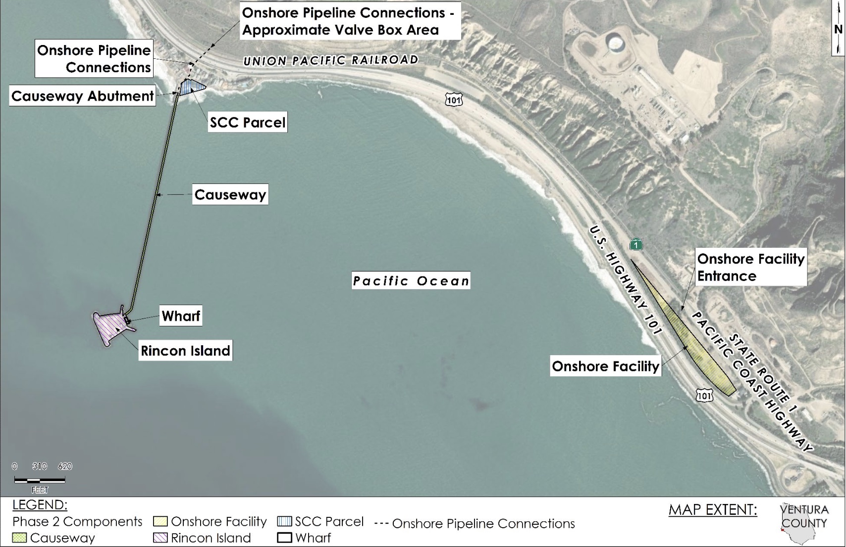
The 2.3-acre manmade island, around 3,000 feet offshore and connected to the mainland by a causeway, was built in 1959 for oil and gas production. The state also owns a 6.1-acre onshore facility at 5750 W. Pacific Coast Highway, 1.3 miles to the east of Rincon Island, that was once connected to the island by a pipeline. In December 2017, Rincon Island Limited Partnership, the most recent lessee of the properties, quitclaimed its lease interests to the CSLC after becoming financially insolvent, and the state of California pursued the decommissioning of Rincon Island.
The decommissioning is being done in three phases.
Phase 1, completed in June 2021, included the plugging and abandonment of all oil and gas wells and removal of service equipment at Rincon Island and the onshore facility. The properties are currently in “caretaker” status—i.e., they don’t require a full-time operator—and overseen by a company called Driltek.
Phase 2 evaluated three scenarios for Rincon Island via a Decommissioning Feasibility Study, completed in July 2022.
Reefing: Remove everything but the island, where structures and pavement would be replaced with clean fill to a condition consistent with use as habitat for wildlife species.
Reuse: The remaining structures and pavement would be replaced with clean fill so as to prepare the island for a potential lessee; a separate evaluation of any proposed use would subsequently occur. The causeway would be left intact and available for use in some form.
Removal: Rincon Island would be removed down to the seafloor.
In August 2022, the CSLC chose to pursue the Reuse option and hired a firm to create an Environmental Impact Report. On March 15, 2024, a draft Environmental Impact Report was released, with a 60-day public review period. The CSLC will host two public meeting sessions on May 2 to receive comments on the draft; you can also email decommissioning ideas and comments to [email protected]. The final Environmental Impact Report will be considered by the CSLC later this year, likely in August.
Phase 3 is to execute the decommissioning plan for the disposition of Rincon Island, the onshore facility, and the causeway. “Disposition” means the final decision on what will be done with the Island, whatever that may be. Proposals for future use remain unresolved.
Got a question you’d like investigated? Email [email protected] or text 917-209-6473.
················
Previous Burning Questions:
••• What happened to the gas flame on Highway 101?
••• What do we know about the proposed apartment complex at 1 Hot Springs Road?
••• What’s the history of this tower on Ortega Ridge?
••• What’s up with these sculptures on a hillside in Summerland?
••• Is there a master plan for the new walking paths in Montecito?
••• Why are the Thousand Steps still wet?
••• What’s happening with Sola Street?
••• Why are trees being cut down above the San Ysidro Ranch?
••• Why is this lot on Milpas Street still vacant?
••• Where else do cruise ships that visit here go?
••• What’s happening with the Pepper Tree Inn?
••• What is this large memorial in Ennisbrook?
••• What’s the large building under construction next to Highway 101?
••• Who bought the former St. Mary’s seminary—and why?
••• What will happen to the SBPD building when the new building is completed?
••• How does the city decide to mark bike lanes?
↓↓↓ What’s the story with this house on W. Cota Street?
••• What are those little houses on Santa Barbara Street?
••• Which Highway 101 exits are getting renamed?
••• Is the Music Academy of the West adding pedestrian gates?
••• Why does the Coast Village Road median look so bad?
••• What’s the point of this light pole near the freeway?
••• Why are the city’s parking lots scanning license plates?
••• What’s inside Paseo Nuevo’s State Street tower?
••• What’s the point of these markings on Laguna Street?
••• Why is there a giant red shoe off Highway 101?
••• Are we no longer allowed on the SBHS baseball field?
••• What does “SBTP” on this post mean?
••• What’s up with the “no e-bike” signs on local trails?
••• Why is Franceschi House in a holding pattern?
••• Why is there a train station inside this State Street storefront?
••• What’s happening with this derelict house in Summerland?
••• Why is there wood on some power lines?
••• Can you explain how sundowner winds work?
••• Why is there a pressure cooker attached to this utility pole?
••• What’s this concrete ramp thing on East Beach?
••• Why does “USA” get written on the street?
••• What are those poles in the ocean near the Ritz-Carlton Bacara?
••• Are people really allowed to set fires in the middle of Montecito?
••• What’s the story with the half-finished lot next to the Montecito Country Mart?
 ················
Sign up for the Siteline email newsletter and you’ll never miss a post.


Fun fact: Rincon Island is Santa’s Landing Pad
Relevant around Christmas, but true any time of the year. A great thing to tell your kids as you drive up to Santa Barbara on the 101, Is that the lights from the oil platforms are Santa and his reindeer. As you drive north on the freeway, those lights get “closer” and will “land” on Rincon Island and the connecting bridge like a plane at an airport. Don’t believe me? Watch the row of lights as you drive and you’ll see it for yourself. Great for kids on the edge of being skeptical about Santa. :-)
I thought the harbor restaurant had a stop work order.? I walked by there today and I witnessed people working. Do you know if they have permission to be working?
Curious Karen