
A client asked about the apartment complex in the works at 1 Hot Springs Road. Have you heard anything about it? Any idea when it might break ground? —J.
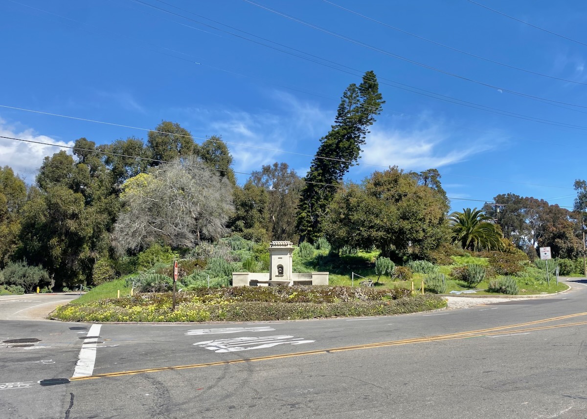
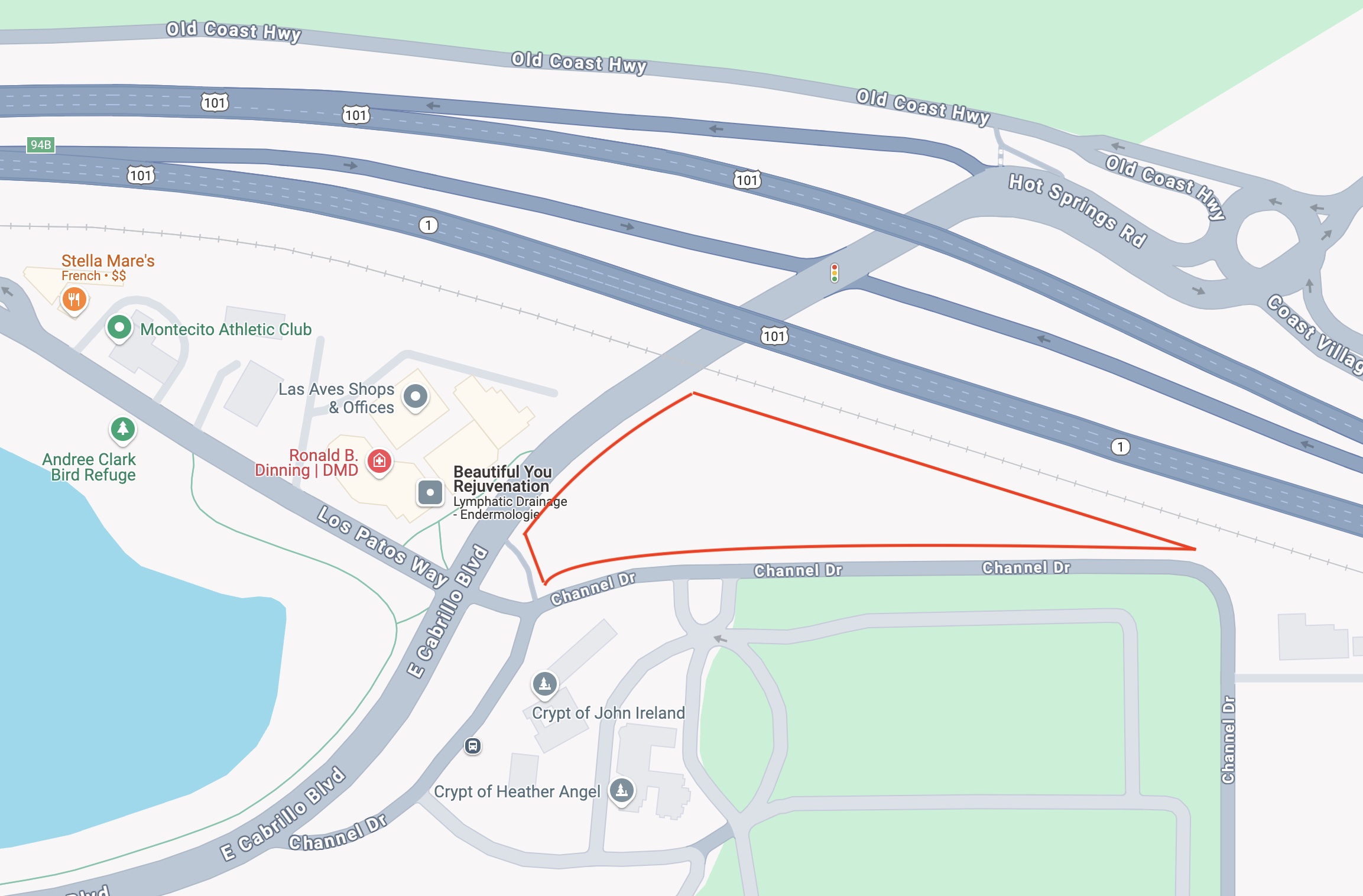
In January, the Independent reported that 1 Hot Springs Road is among the projects using the state’s “builder’s remedy” provision, which allows developers to construct housing even if the local government objects. (It was triggered by the city and county missing their Housing Element deadlines.) The plan called for a 27-unit development on the 2.4-acre vacant lot across Channel Drive from the Santa Barbara Cemetery. You may know it better as the lot with the fountain at the corner.
It’s private property, so you’d obviously be foolish to go see what it looks like for yourself.
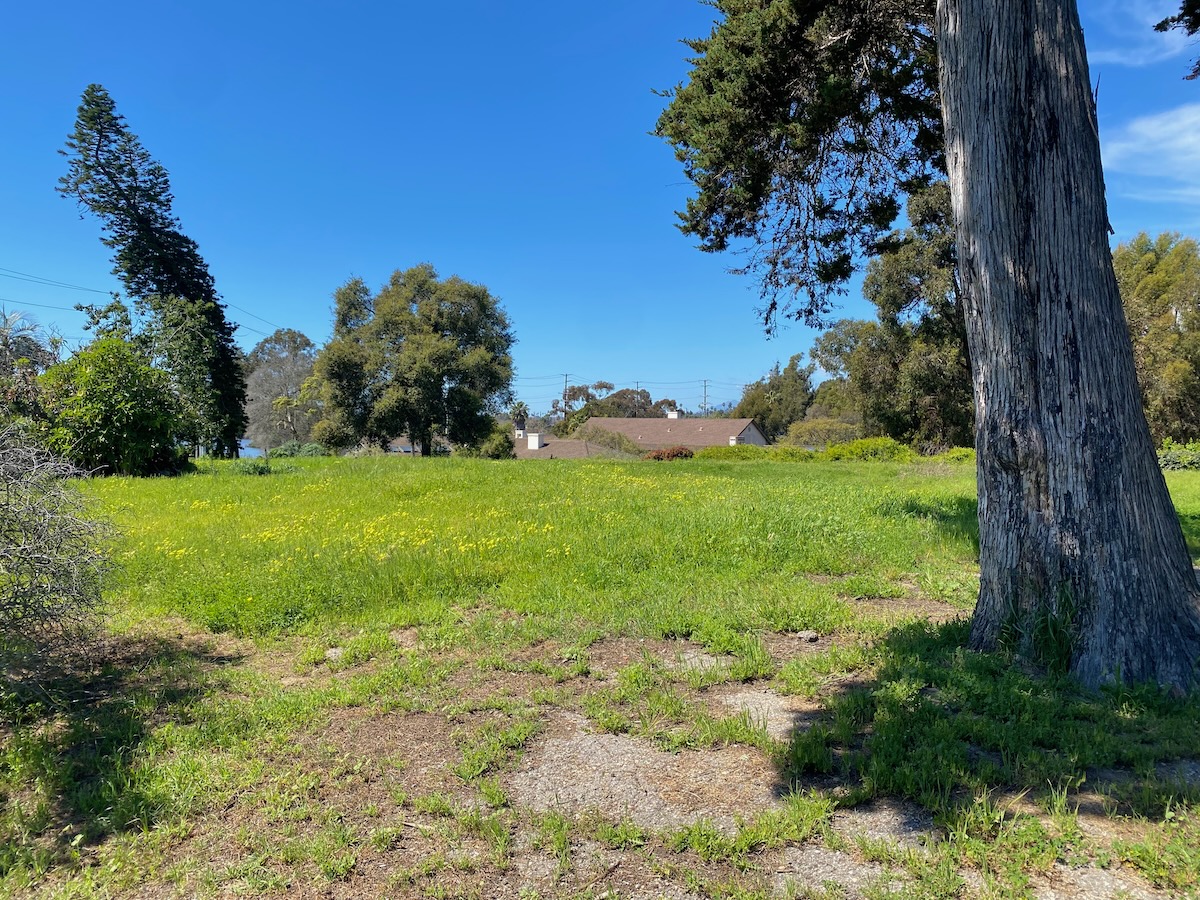
 The plans are in a pre-application phase, which means they have yet to appear on any agendas. I had to visit the city’s Planning Division to see what they might show me. The lot is owned by the Santa Barbara Cemetery Association, which has issued a ground lease to a developer for the housing project.
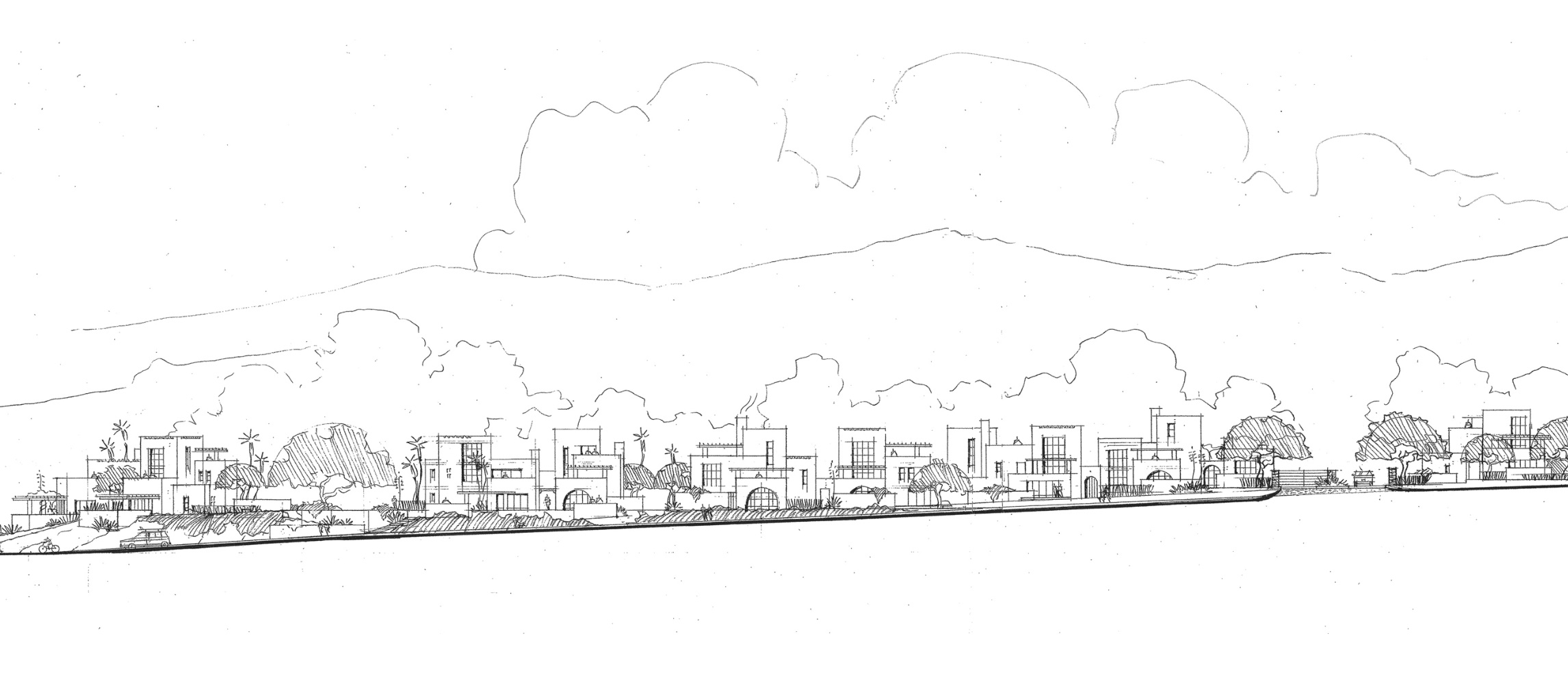
The developer agreed to talk to me about the project. Initially, they were looking at as many as 60 units on the lot, with underground parking, but that didn’t feel right for the location. They reduced the number to 27 units, all rental townhomes with private garages, in 15 or so buildings placed around the perimeter. The idea is to make it feel, as much as possible, like an Upper Village street. Designed by DesignARC, the structures are flat-roofed, of various heights, with a lot of offsets. At least 20 percent will be classified as affordable housing. The complex will likely end up with a Channel Drive address, which is both more logical (apparently, before the freeway was built, Hot Springs extended all the way to Channel Drive) and appropriate (since the entrance is on Channel Drive).
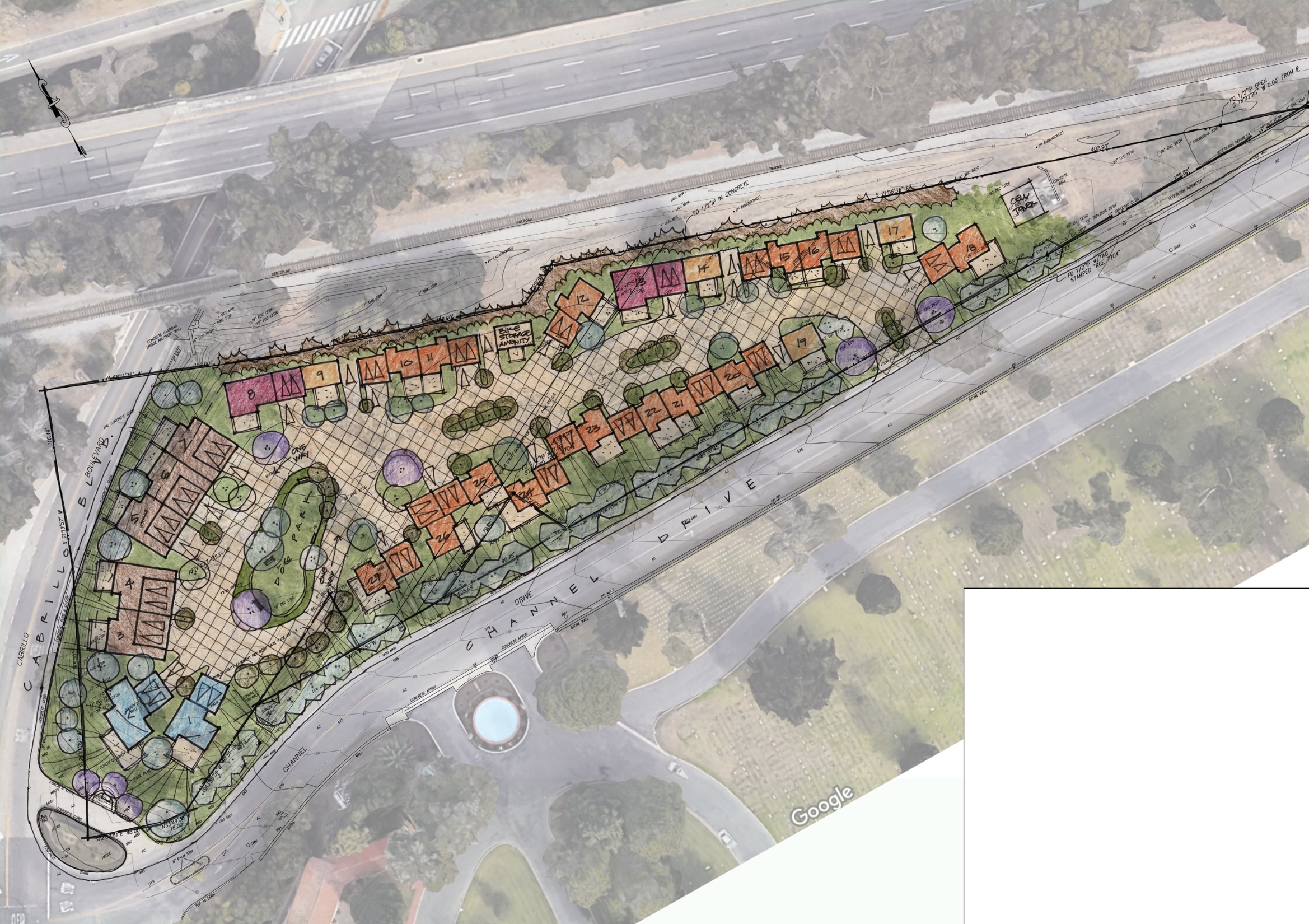
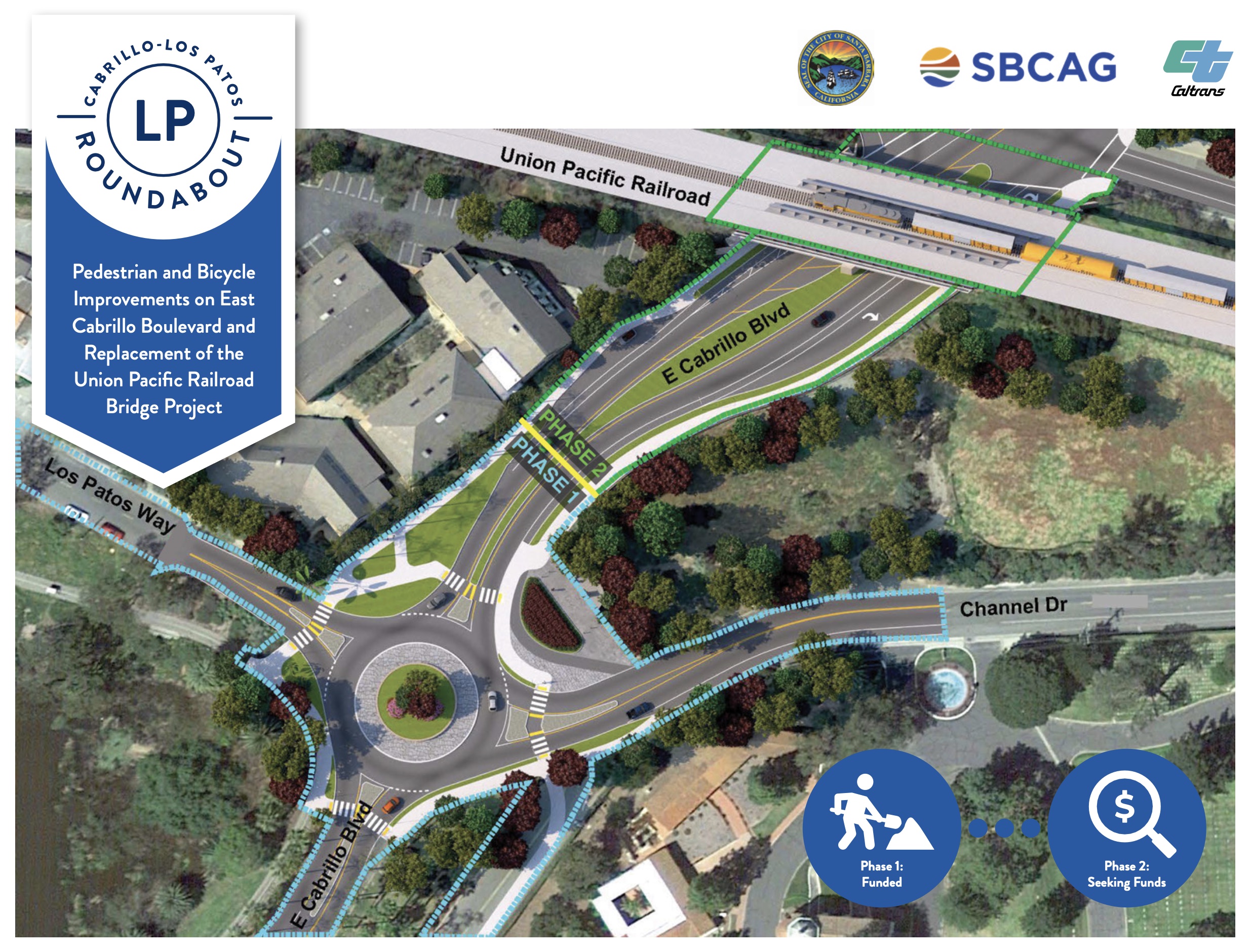
 When this might happen is anyone’s guess—the project is expected to be formally submitted soon, and then there’s still a certain amount of red tape. And of course a lot of construction is coming to that area: the intersection of Cabrillo Boulevard and Los Patos Way will converted to a roundabout, and the widening of Highway 101 involves completely redoing the interchange with Cabrillo Boulevard/Hot Springs (including new overpasses). Some good news for those of us who ride a bike around there: the second phase of the Los Patos roundabout project involves taking a slice of the 1 Hot Springs lot by eminent domain, in order to build a new bike path on the east side of Cabrillo.
 Got a question you’d like investigated? Email [email protected] or text 917-209-6473.
················
Previous Burning Questions:
••• Why is the Castillo Street undercrossing always wet?
••• What’s the history of this tower on Ortega Ridge?
••• What’s up with these sculptures on a hillside in Summerland?
↓↓↓ Is there a master plan for the new walking paths in Montecito?
••• Why are the Thousand Steps still wet?
••• What’s happening with Sola Street?
••• Why are trees being cut down above the San Ysidro Ranch?
••• Why is this lot on Milpas Street still vacant?
••• Where else do cruise ships that visit here go?
••• What’s happening with the Pepper Tree Inn?
••• What is this large memorial in Ennisbrook?
••• What’s the large building under construction next to Highway 101?
••• Who bought the former St. Mary’s seminary—and why?
••• What will happen to the SBPD building when the new building is completed?
••• How does the city decide to mark bike lanes?
••• What’s the story with this house on W. Cota Street?
••• What are those little houses on Santa Barbara Street?
••• Which Highway 101 exits are getting renamed?
••• Is the Music Academy of the West adding pedestrian gates?
••• Why does the Coast Village Road median look so bad?
••• What’s the point of this light pole near the freeway?
••• Why are the city’s parking lots scanning license plates?
••• What’s inside Paseo Nuevo’s State Street tower?
••• What’s the point of these markings on Laguna Street?
••• Why is there a giant red shoe off Highway 101?
••• Are we no longer allowed on the SBHS baseball field?
••• What does “SBTP” on this post mean?
••• What’s up with the “no e-bike” signs on local trails?
••• Why is Franceschi House in a holding pattern?
••• What’s happening with this derelict house in Summerland?
••• Why is there wood on some power lines?
••• Can you explain how sundowner winds work?
••• Why is there a pressure cooker attached to this utility pole?
••• What’s this concrete ramp thing on East Beach?
••• Why does “USA” get written on the street?
••• What are those poles in the ocean near the Ritz-Carlton Bacara?
••• Are people really allowed to set fires in the middle of Montecito?
••• What’s the story with the half-finished lot next to the Montecito Country Mart?
 ················
Sign up for the Siteline email newsletter and you’ll never miss a post.


Here’s some good trivia and I swear it’s not an April Fools joke. That tree you see leaning to the right is a Cook Pine, native to New Caledonia. It’s unique that it leans to the south in the northern hemisphere, the farther away from the equator the more it leans. And south of the equator it leans north.
Great intel! Will be a lot of changes there between the new roundabout, this development, and the new Post/former Las Aves property!
What’s the significance of the fountain on that corner? Is it going to be removed as part of the new development?
fwiw it looks like the fountain is being kept – it’s in the lower left corner of the top view of the development renderings.
I hope they save the fountain and improve the landscaping to coordinate with round about. This will be a nice improvement along with the high end shopping and dining across from the bird refuge.