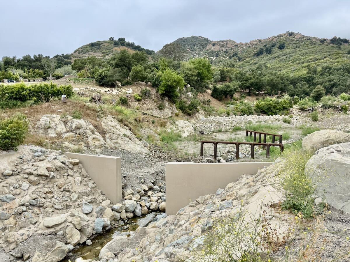
It looks like the San Ysidro Debris Basin is done. Can you ask an engineer what the point of the three structures is? —N.
During most storm flows, the goal is for everything to continue downstream. In a major flow or debris flow, however, large material will ideally stall in the basin, while smaller sediments continue onward. “In San Ysidro Creek, there used to be an earthen dam with a concrete cap on top and a 48-inch-wide pipe going through it,” explains Seth Shank, Regulatory Compliance Manager for Santa Barbara County Flood Control. “The thought was that it would capture anything over 48 inches wide. But we learned over the years that the culvert pipe would get overwhelmed and back up, and then finer stuff would become trapped.”
And in the 2018 debris flow, the county discovered that the broad, flat basin does more than the dam to slow down the debris coming from the steep, narrow channel upstream. “Once the velocity is reduced, the big material stays in the basin instead of carrying through,” says Shank.
The new concrete structure is designed to hold water back, the better to lower the speeds of what’s coming downstream, with an opening the width of the natural channel to allow for the passage of fish (the southern steelhead trout, in particular). As for the two metal debris racks, they might trap some rocky material, but they’re really meant to catch floating woody debris that could cause blockages downstream. They’re angled that way to avoid complete blockage, and so that if the top rack gets filled, the second one can catch more.
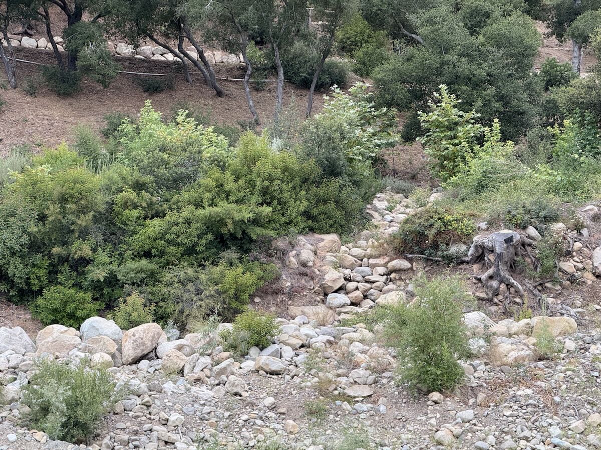
P.S. When I went to take the above photo, I noticed what look like stone steps on the San Ysidro Ranch side of the creek. “Those are actually drainage swales for runoff during rain events, with rock placed there to prevent erosion,” says Shank.
 ················
Previous Burning Questions:
••• What’s this building on Helena Avenue?
••• What are those old pilings in Arroyo Burro Creek?
••• What’s this building under construction in Toro Canyon?
••• What’s the story behind the seal of the City of Santa Barbara?
••• Butterfly Beach steps, green power lines, SBAG license plates, and more
••• What’s this pole with a flashing blue light?
••• What are these sculptures on the Riviera?
••• What’s the origin story of this fence on Hot Springs Road?
••• What’s the housing development under construction next to the polo fields?
••• Why is part of this West Beach mosaic covered in concrete?
••• What was the Weeping Willow Inn?
••• What does the “S” on certain chimneys stand for?
••• What’s the status of the decommissioning of Rincon Island?
••• What happened to the gas flame on Highway 101?
••• What do we know about the proposed apartment complex at 1 Hot Springs Road?
••• What’s the history of this tower on Ortega Ridge?
••• What’s up with these sculptures on a hillside in Summerland?
••• Is there a master plan for the new walking paths in Montecito?
••• Why are the Thousand Steps still wet?
••• What’s happening with Sola Street?
↓↓↓ Why is this lot on Milpas Street still vacant?
••• Where else do cruise ships that visit here go?
••• What is this large memorial in Ennisbrook?
••• Who bought the former St. Mary’s seminary—and why?
••• What will happen to the SBPD building when the new building is completed?
••• How does the city decide to mark bike lanes?
••• What’s the story with this house on W. Cota Street?
••• What are those little houses on Santa Barbara Street?
••• What’s the point of this light pole near the freeway?
••• What’s inside Paseo Nuevo’s State Street tower?
••• What’s the point of these markings on Laguna Street?
••• Why is there a giant red shoe off Highway 101?
••• What’s up with the “no e-bike” signs on local trails?
••• Why is Franceschi House in a holding pattern?
••• What’s happening with this derelict house in Summerland?
••• Can you explain how sundowner winds work?
••• Why is there a pressure cooker attached to this utility pole?
••• What’s this concrete ramp thing on East Beach?
••• Why does “USA” get written on the street?
••• What are those poles in the ocean near the Ritz-Carlton Bacara?
••• Are people really allowed to set fires in the middle of Montecito?
••• What’s the story with the half-finished lot next to the Montecito Country Mart?
················
Sign up for the Siteline email newsletter and you’ll never miss a post.


I assumed the 3 structures were just more affordable housing because everyone deserves the right to live in the nicest areas am I right?
Thanks for the great newsletter. When will Randall Road debris basin be open for hiking?
The metal structures (designed to catch woody debris) could be improved. I have no idea if there are existing standards but back of the napkin/top of the keyboard “improvement” could be something on the side that, to face the upstream could look like an array of |\ but angled at about 45 degrees, constructed in the center half of the presumed “river”, to elevate tree/brush elements upward and block them there, partly out of the water and allowing passage of water under and around. I could even be a bit of an arc instead of a linear block, looking from top down looking like (_ with (- and (top line). Just sayin.